DLR
EOC
degree of urbanization
urban
rural
spatial statistics
building density
population density
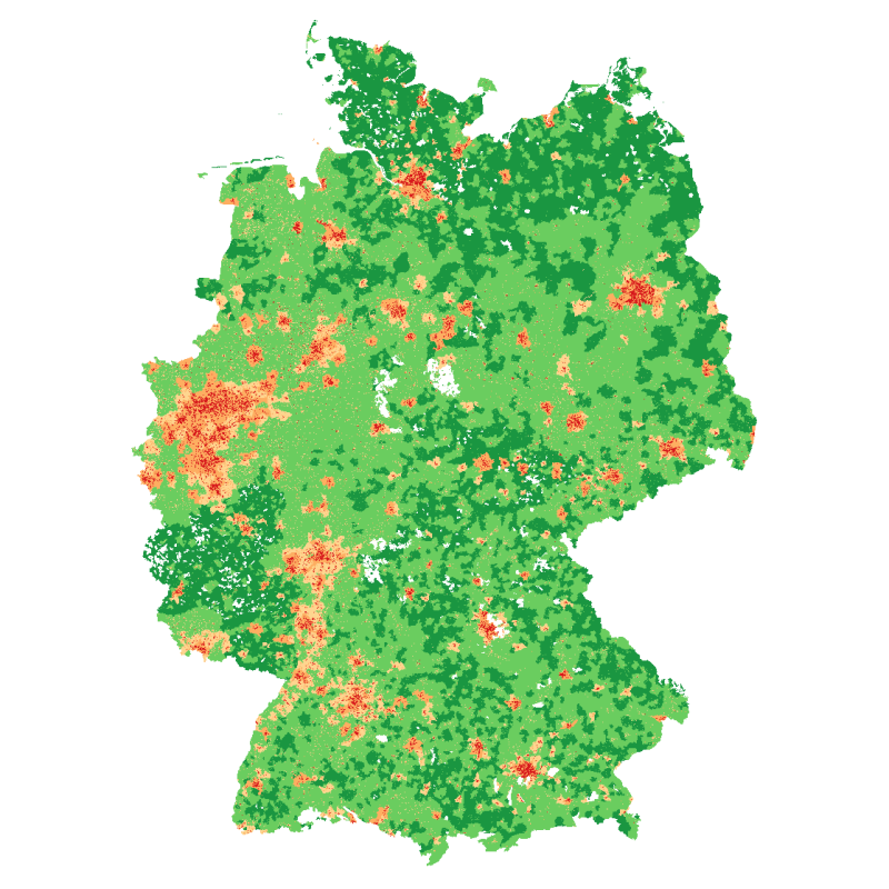
The degree of urbanization provides urbanization level information at 100x100 meter grids for Germany. It is based on population numbers, building density and the share of building types. It is provided as a continuous percentage value representing the probability of the degree of urbanization, as well as five discrete values representing classes of the degree of urbanization: definitely ‘urban’, probably ‘urban’, area of uncertainty, probably ‘rural’, definitely ‘rural’.
The “Degree of Urbanization” was created based on 29 different urbanization layers, which reflect various definitions of “urban space.” Fifteen definitions are based on administrative interpretations of “urban space.” These definitions were applied to Germany from various countries around the world. The remaining 14 layers were generated using variable threshold values at the grid level. These define the degree of urbanization according to different thresholds (i.e. 1%, 25%, 50%, 75%, and 99%) based on different variables, such as the proportion of built-up area, the number of inhabitants, or the proportion of multi-family houses. These 29 layers were superimposed and intersected with each other across the entire study area to obtain a probability of the degree of urbanization.
References:
- Taubenböck H, Droin A, Standfuß I, Dosch F, Sander N, Milbert A, Eichfuss S, Wurm M (2022): To be, or not to be ‘urban’? A multi-modal method for the differentiated measurement of the degree of urbanization. Computers, Environment & Urban Systems 95,101830. https://doi.org/10.1016/j.compenvurbsys.2022.101830 DOI: https://doi.org/10.1016/j.compenvurbsys.2022.101830
- Taubenböck H, Droin A, Standfuß I, Gähler M, Milbert A, Sander N, Eichfuss S, Dosch F & Wurm M (2023): Eine Differenzierung der Stadt-Land Dichotomie: ein wahrscheinlichkeitsbasierter Ansatz. BBSR – Bundesinstitut für Bau-, Stadt- und Raumforschung im Bundesamt für Bauwesen und Raumordnung (BBR) (Hrsg.), Die Abgrenzung des ländlichen Raums – ein (un)mögliches Unterfangen? Dokumentation des BBSR-Online-Workshops am 29. April 2022. S. 44-53. Link
Items:
This layer shows the classification into 5 categories of the degree of urbanization in Germany in 2018.
This layer shows the probability of the degree of urbanization in Germany in % in 2018.