DLR
EOC
TDM
TanDEM-X
DEM
Digital Elevation Model
TDM-DEM-90m
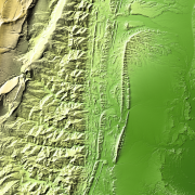
TanDEM-X (TerraSAR-X add-on for Digital Elevation Measurements) is an Earth observation radar mission that consists of a SAR interferometer built by two almost identical satellites flying in close formation. With a typical separation between the satellites of 120 m to 500 m a global Digital Elevation Model (DEM) has been generated.
The TanDEM-X 90m DEM is a product variant of the global Digital Elevation Model (DEM) acquired in the frame of the German TanDEM-X mission between 2010 and 2014, and has a reduced pixel spacing of 3 arcseconds (arsec), which corresponds to 90m at the equator. It covers all Earth’s landmasses from pole to pole.
References:
- Grohmann, C. H. (2018), Evaluation of TanDEM-X DEMs on selected Brazilian sites - Comparison with SRTM, ASTER GDEM and ALOS AW3D30 Remote Sensing of Environment, Vol. 212, pp. 121-133.
- Wessel, B., Huber, M., Wohlfart, C., Marschalk, U., Kosmann, D., Roth, A.(2018), Accuracy Assessment of the Global TanDEM-X Digital Elevation Model with GPS Data. ISPRS Journal of Photogrammetry and Remote Sensing. Vol. 139, pp. 171-182.
- Rizzoli, P., Martone, M., Gonzalez, C., Wecklich, C., Borla Tridon, D., Bräutigam, B., Bachmann, M., Schulze, D., Fritz, T., Huber, M., Wessel, B., Krieger, G., Zink, M., and Moreira, A. (2017), Generation and performance assessment of the global TanDEM-X digital elevation model. ISPRS Journal of Photogrammetry and Remote Sensing, Vol 132, pp. 119-139.
- Wessel, B. (2016), TanDEM-X Ground Segment: DEM Products Specification Document. EOC, DLR, Oberpfaffenhofen, Germany, Public Document TD-GS-PS-0021, Issue 3.2, 2016. [Online]. https://tandemx-science.dlr.de/
- Zink, M., Bachmann, M., Bräutigam, B., Fritz, T., Hajnsek, I., Krieger, G., Moreira, A., Wessel, B., TanDEM X - The New Global DEM Takes Shape, IEEE Geoscience and Remote Sensing Magazine (GRSM), 2(2), pp. 8-23, 2014.
- Krieger, G., Zink, M., Bachmann, M., Bräutigam, B., Schulze, D., Martone, M., Rizzoli, P., Steinbrecher, U., Antony, J.W., De Zan, F., Hajnsek, I., Papathanassiou, K., Kugler, F., Rodriguez Cassola, M., Younis, M., Baumgartner, S., López-Dekker, P., Prats, P., Moreira, A., 2013. TanDEM-X - a radar interferometer with two formation-flying satellites. Acta Astronaut. 89, 83-98. August-September.
- Krieger, G., Moreira, A., Fiedler, H., Hajnsek, I., Werner, M., Younis, M., Zink, M., 2007. TanDEM-X - a satellite formation for high resolution SAR interferometry. IEEE Trans. Geosci. Rem. Sens. 45 (11), 3317-3341.
Items:
The AM2 layer contains the minimum value of all calibrated amplitude values from the contributing DEM scenes (in general between 2 and up to 10 scenes).
The AMP layer contains the mean value of all calibrated amplitude values from the contributing DEM scenes (in general between 2 and up to 10 scenes).
The consistency mask (COM) indicates DEM pixels, which have height inconsistencies among the contributing DEM scenes.
The coverage map (COV) indicates how many valid height values from different DEM acquisitions were available for mosaicking.
The DEM elevation values represent the ellipsoidal heights relative to the WGS84 ellipsoid in the WGS84-G1150 datum.
The height error map (HEM) values represent for each DEM pixel the corresponding height error in form of the standard deviation.
The layover and shadow mask (LSM) is based on the SRTM-C DEM and the GLOBE DEM regarding the TanDEM-X geometry of each individual scene.
The water indication mask (WAM) layer represents the water bodies indentified during processing.
Related Datasets:

TanDEM-X PolarDEM 90m of Antarctica
2023-11-15
TanDEM-X 30m Edited DEM (EDEM)
2023-11-15

TanDEM-X 30m DEM Change Maps (DCM)
2023-11-15
